The Most Amazing Place in the World.
It was a great trip. However, it wasn’t the trip I’d planned as Mom had twisted her ankle two weeks before while she was visiting my brother out at Salt Spring in BC. Walking far was not on her agenda which put a bit of a damper on her hiking. My cell phone never worked after leaving Pearson, not even in St. John’s. Since Mom wasn’t up to walking, I didn’t want to leave her anywhere where she couldn’t contact me so we stuck pretty close together the whole time. There would be no off road adventure this time. I had planned this trip as a thank you for my 86 year old Mother who had always made sure that I got to experience the things in life that I wanted and I needed to show her the most amazing place in the world.
I had to take a bit of time before I wrote about the trip. I wanted the good stuff to settle in as lots went wrong and I was afraid I would dwell on that. We had a great deal of rain every day. ‘Writers at Woody Point’ was an amazing literary festival. The location was fabulous and totally suited to the events. It’s too bad it was so far removed from St. John’s but I guess that was part of the charm. Newfoundland was such a freaking big island.
I had no idea that I would not have cell phone service there. Eventually, I would get service in downtown St. John’s. In December, I had made reservations at Crocker Cabins, a bit out of town at Trout River. I hoped Mom would be comfortable there if I found someone with whom to hike. The other guests stayed in their rooms so she didn’t meet anyone. I did not feel that I could leave her alone, so I didn’t. It was obvious that I would need to make next year’s reservations before we left to ensure accommodations without the daily trek.
At the festival, I heard great writers and storytellers so I left a fair bit of cash in Gros Morne buying books and music. I needed another suitcase just for the books. The rain didn’t really keep us from doing things each day but we were always late getting started since it was most often raining when we rose. Back and forth to Woody Point each day was a bit tiring for Mom. On the weekends there were two performances daily, so we did it twice a day.
Our journey was completely smooth until we got to the Deer Lake airport; there was no car. It seems they were expecting us at the downtown location so our car was given away. The car eventually came. It was a Grand Prix. A little bigger than the Yaris we ordered. This could be a good thing. As we left the airport, the light was beginning to fade but we pressed on. As we turned off the Trans Canada Highway, locally known as the TCH, the road conditions deteriorated, but at least I could see the centre line. The sunset was amazing over the mountains but there was nowhere to pull off. We were heading west so I hoped we could catch the sunset on a rise. Soon after that, Mom starting to get anxious. She didn’t say anything in particular but I could tell in her voice each time she asked, “How much further?” Her seat was quite low down and she’d lost some height from osteoporosis. It must have been like being a kid in the back seat of Dad’s huge Impala on the way to the cottage when all you could see looking up out the windows was the light filtering through the trees. Up and down, down and up along the gravel road north out of Havelock… Up and down, down and up. The sun had set in the valleys but the tops of the mountains had a glow of purple on the tips. There was a huge grade coming down into Glenburnie which went down about a kilometer and a half. Straight down, no curve. No emergency run off. “Test your brakes” it would have said in West Virginia, but this was Newfoundland. The only signs pictured a crushed car next to a monstrous moose.
Mom was panicky that she could not see the road and probably thought that I could not as well. I felt familiar with the area even though I could not see a thing beyond the edge of the road. I had driven it so many times in my mind. I counted off the towns one by one to Mom: Wiltondale, Glenburnie, Birchy Head, Shoal Brook, Woody Point. It was pitch black by now. We followed route 431 out of Woody Point around a steep sharp left-handed upward curve on the way to our destination.
“One more town, Mom.”
“How far is that?”
“Eighteen kilometers!”
“Oh my gawd!” she exclaimed.
Looking back on that made me laugh for the rest of our journey.
At about the fifteen kilometer mark, between the mountains, I could see the flat surface of the Gulf of the St. Lawrence and knew we were nearly there. The twinkling lights of the town sparkled in the valley. Trout River. Now all we had to do was find our cabin.
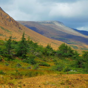
The drive back into Woody Point was much improved over the night before. Although overcast with low clouds, the area was a sight to behold. On our right were the majestic reddish orange Tablelands, born out of the earth’s mantle rising 700 meters above with a gentle concave slope. On the other side of the road in direct contrast, the Gabbro rocks formed the inverse convex slope. They were hard and domed but unlike the peridotite of the Tablelands; the Gabbro can sustain botanical life. They were lush and green with the stunted tuckamore. There were many trails and parking areas to stop and enjoy the view. Mom would become all too familiar with these. The trails in this area were pretty rugged and not suited for Mom, so I guessed we wouldn’t be hiking any of these. I’d save her strength for Prescott Street in St. John’s.
Lunch at Cow Head seemed a good idea and along the way we stopped at Western Brook Pond trailhead for some photos. Oh my. What a sight. The low clouds were blue grey, green, and purple. I could not believe that I was here to capture this. I have dreamed of this sight. I did not want to move from this spot. I kept watching to see the light changing. It moved in and out of the clouds, highlighting and shadowing the gigantic cliffs of the gneiss fjords. In front of me was the peat and muck that form bogs and fens which overlay the limestone bedrock. Mounds and ridges of till blanket the sandstone that had been formed in deep water and pushed here many thousands of years ago. It was about then that I realized my camera had reverted to some obscure white balance and was set for incandescent light; the shade of blue in my pictures was spectacularly eerie. Time to learn some Photoshop techniques. On the return trip we stopped again at this trailhead; now the sky had cleared and the sun shone on the north face of the cliffs. These were all new colours, a little more rust and the deep etched cliffs became more prominent.
Every few miles we saw the warnings to watch for moose. We both called out ‘watch for moose’, partly to acknowledge the sign and partly to make note of how often we saw the sign. Payoff! There was a moose feeding in the ditch, nose in the bush. I braked carefully after checking the rear view to make sure no one was on my tail. I wanted to get a good view as well as to ensure he didn’t turn and run into my path. There was no antler rack. I’m not sure if that meant it was a female or just immature. Mom got a good glimpse before I resumed cruising speed. I would have liked to pull off but there was very little shoulder and we were on the Viking Trail, the truck route to and from St. Anthony with a posted speed of 100kmh.
The flight to St John’s was less than an hour in the six passenger prop plane. The Captain cruised at a low altitude so we could take in the landscape from a different perspective. The sun decided to keep the clouds away and skies were almost clear so it seemed like a perfect chance to head up to Signal Hill and see if there was a view. It was wonderfully grand. The sun was shining on the Southside Hills and most of the town was in the shadow of the headlands. Cabot Tower stood out in all its majesty and tourists were perched on the upper observation decks. Massive black clouds looming in the west looked like they were ready to drop wild water on the city. We had to move fast but I could see some great photo opportunities on the horizon. For me, the emotion I felt on top of Signal Hill was euphoria. I could sit there for hours watching the sea, watching the clouds, feeling the salt air fresh on my skin. It felt like being on the edge of the world and nothing is in the way of your dreams. The wind makes you know you are alive. There’s a beauty that lets you feel as if you are standing next to God. It is something that you have to experience for yourself, and ‘see the world from way up here’.
A few days after the return to Toronto we had a fresh fish lunch at the Old York with a long time friend, Yvonne. Mom had me retelling the stories about the car, about the roads, about the tablelands, about the tuckamore, about the moose, about the tower. She couldn’t remember everything she saw. I remarked on how we would make some changes next year. Next year? You want to take me back? Yvonne remarked about mom’s comments last Christmas when she received the trip as a gift. She was apprehensive; she figured she’d be dead by then or worse, die there. I prepared an album for Mom with photos of all the crazy colours, the rain and the rocks. Mom carried it around with her like it was a piece of gold. She took it to the girls having coffee; she took it to line dancing; she took it to the hairdressers, and I bet she even took it to church. She was so proud of that book, she was afraid to call me and tell me that she had lost it.